Les Pyrénées
High Mountains on the
Border with Spain
Walking in the Pyrénées
The Pyrénées offer some of the most stunning and challenging walking in France.
We have explored parts of these great mountains on several trips, in varying
weather and different seasons, sometimes on foot and sometimes with the
mobility of a rented car.
We have stood on the Atlantic coast at Hendaye and looked east to where the
mountains begin. We have visited St Jean Pied de Port and walked up the GR 65
towards the Spanish border. Further east we have navigated the Col d'Aubisque
and the Col du Tourmalet, stayed in Gavarnie and Cauterets and walked in the
shadows of Vignemale. Across the Col d'Aspin is the small town of Avajan where
we spent two weeks, walking nearly every day high up in the mountains. Then
finally across the Col de Peyresourde and the Col de Portet d'Aspet, to the
eastern end, below the mountain principality of Andorra, where we have explored
the Catalan country around Canigou and down to the Mediterranean coast at
Collioure.
The GR 10 traverses the length of the Pyrénées on a
long, tough, and undoubtedly wonderful route which
starts at Hendaye and finally comes down to the
Mediterranean at Banyuls. It's even tougher alternative is
the Haute Randonnée Pyrénéenne (HRP) which stays
high in the mountains and close to the frontier with
Spain.
Attempting either of these routes is for the really
committed walker, the very young, the very fit and
perhaps the slightly crazy. An alternative is to
experience the beginning and the end and then, as we
have done, to dip into these wonderful mountains at
various points to experience the absolute exhilaration
of real mountains.
This long chain of mountains, rising up to 3400 m, forms the border
between France and Spain and is characterised by long valleys
running generally in a north-south direction up into the high peaks. The
local word for the rivers that gush down these valleys is gave, or
sometimes, neste. You don't start in one of these valleys and cross
over into the next - unless you are walking the GR 10 or the HRP.
Instead you have to go down to the end of each valley, then take a
route through the comparatively less difficult terrain of the foothills, or
across the high passes made famous by le Tour de France, and then
head up the next valley.
Follow these links for different parts of the Pyrénées
Follow these links for different parts of the Pyrénées
• Cauterets and Vignemale
• The Cirque de Gavarnie
• Avajan, Mountain Lakes and the Reserve Naturelle de Néouvielle
• Canigou and the Catalan Country
• Collioure and the Côte Vermeille
• Spanish Catalonia
• The Cirque de Gavarnie
• Avajan, Mountain Lakes and the Reserve Naturelle de Néouvielle
• Canigou and the Catalan Country
• Collioure and the Côte Vermeille
• Spanish Catalonia
Parc National des Pyrénées
The park was established in 1967 after many years of
opposition from the local communes wishing to maintain
the ancient rights and privileges that were associated
with the mountains. It forms a 100 km long ribbon along
the border, broadening out around the Pic du Midi
d'Ossau between Cauterets and Vignemale, where it
incorporates the Réserve Naturelle de Néouvielle (which
was created in 1935 as France's first protected area).
National parks in France do respect the right of local
people to live and maintain a living in many of the
parks. However the core zone of this park is 45,700ha
in size, all above 1100m, and no settlement is allowed
in this area. A peripheral zone has an area of 206,300
ha, has a population of about 40,000 and is less
stringent in its environmental controls. The head office
of the park in Cauterets has excellent displays and
offers good advice to visitors.
The Border between France and Spain
The frontier runs along the crest of the high peaks of the Pyrénées,
established after centuries of fighting during which the lands straddling
the mountains bounced back and forward between France and Spain.
In 1659 the Treaty of the Pyrénées was negotiated and signed on an
island in the River Sidoasa, upstream of Hendaye. The treaty was not
confined to the Pyrenéean border but also sorted out a number of
disputed territories in northern Europe which Spain lost.
The border was fixed at the Pyrénées, forcing Spain to cede
Roussillon, as far north as Perpignan, and part of the Cerdagne. The
big losers were the Catalans as the new border entirely split their
people and, in political terms, their unity was lost forever.
The treaty was tenuous at first as evidenced by the massive forts
built by the French to maintain their sovereignty. The exact
demarcation was not formally established until 1868 when about
600 border markers were located along the route. Since its
establishment it has, however, been one of the most stable and
peaceable frontiers in Europe.
In the 20th century the frontier on two occasions became a symbol
of freedom and liberty. Catalunya was strongly republican during
the Spanish Civil War and many Republican soldiers, pursued up
into the high valleys, became marooned and fled over the high
passes to France. Many were joined or preceded by their families
and then remained in France.
With World War II came a refugee movement in the opposite
direction, many people making their way south to escape into
neutral Spain from the Nazi occupation of France. A very well
organised escape organisation was established to guide the
refugees across the mountains and it is estimated that in excess of
35000 people escaped to Spain.
The spa town of Cauterets is ideally located in one of the mountain valleys
and makes a good base for walking in the part of the Parc National des
Pyrénées that is dominated by the mighty Vignemale. Walks start in
Cauterets or higher up at Pont d'Espagne, an amazing place which floats
in a mist of spray in the middle of several gushing waterfalls. There is
nothing there except an old stone bridge, a car park, a range of tourist
facilities and a telesiège.
There are day walks or circuits of several days, so you can choose either
to make a base in Cauterets and walk for single days, or to do one of the
longer circuit, staying overnight in mountain refuges. There is an
enormous variety of walking - through woodlands, circuiting lakes,
scrambling up towards the high summits or meandering through the
meadows that lie between the peaks. We chose to stay a few nights in
Cauterets and did two day walks from Pont d'Espagne.
Cauterets
Cauterets, though a thriving town based on its thermal baths and mountain
activities, has an air of faded Victorian elegance. Many of the thermes are
still in use, though some have been turned to more contemporary uses
such as pin ball parlours. Along the roadside each establishment
advertises its cures, some specialising in rheumatism, others in asthma or
bronchial diseases. There seemed to be a particular emphasis on ear, nose
and throat complaints. The overpowering smell of sulphur fills the air and
doesn't seem very healthy at all.
Along with the thermes go the Grand Hotels built in a neoclassical style and taking up
whole street blocks. There are numbers of these, plus dozens of more modest
establishments - hotels, apartments and guesthouses - where you book in for "le
cure". We chose the Hotel Centre Poste where demi pension gave us dinner, bed and
breakfast. At dinner, everyone had individual table napkins in personalised rings and
wine bottles were recorked and returned to diners each night with the level
imperceptibly lowered. We sensed a hint of disapproval as our bottle was dispatched
in a single sitting. The curists discussed the day's activities in hushed tones, watched
television and shuffled off to bed.
This was June and when the clouds lifted up from the valley, the jagged snow covered
mountain peaks that surround the town astonishingly emerged into view. Magic.
Accompanying the awesome scenery is the overwhelming presence of water.
Alongside the hotel was a channel in which the Gave de Cauterets roared through the
town. All the way up the mountain road cascades of water spilled down the hillsides
eventually to join the gushing gave below. At Pont d'Espagne three powerful gushes of
foaming water join together to make a super gush, heading down the mountains in
one gigantic gushing cascade after another.
Thermes
The healing benefits of hot springs and mineral
waters have been known since pre Roman times.
Spa towns, or thermes, became fashionable centres
of health tourism, reaching their peak of popularity in
France in the late 19th century. At this time there
were more than one thousand establishments
throughout the country, made more accessible by
the growing network of railways.
The development of Cauterets as a spa town
began in the 900's when the monks of the
monastery of Saint-Savin decided to exploit the
spa waters as a commercial venture. They were
assisted by a local nobleman, Count Raymond de
Bigorre, who provided the financial support needed
to establish the town and its spas.
In the 16th century Marguerite de Navarre became a
regular visitor and was perhaps staying here when
she wrote some of her famous Heptameron - a
French equivalent of the Decameron. Many other
writers and royalty followed. Among the writers were
Francois Rabelais, George Sand, Gustave Flaubert
and Victor Hugo and Alfred Tennyson.
Once regarded as the domain of the rich and
privileged classes, the effectiveness of the cures
is now recognised by the health authorities who
make provision for their inclusion in social security
benefits.
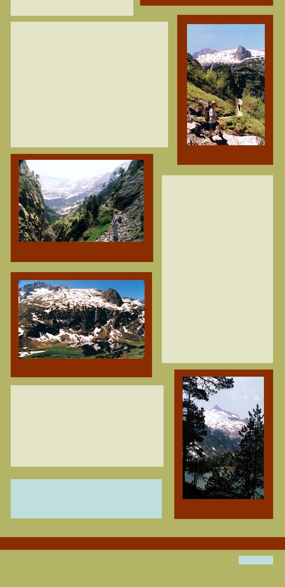
Discovering Vignemale
We did two walks which could otherwise be linked together to make a
three-day circuit. The first was up the Vallée du Marcadau to the
Refuge Wallon, following a classic glacial valley, crossing the gushing
streams, with water cascading down into the valley and spilling
everywhere. Snowy peaks were all around and little marmots
scampered away to hide among rocky outcrops. Returning the same
way, the appetite was whetted for the second days walk up to the
base of Vignemale.
Again from Pont d'Espagne, we took the bite out of the climb by
riding up in the telesiège to the Lac de Gaube. After walking around
this not very interesting lake, the climb started - up the Vallée of the
Gaube, continually crossing this busy little stream until we reached
the wide meadows of moraine which in springtime were full of
wildflowers. Once up here the view of Vignemale is magnificent and
the atmosphere charged with the exhilaration of such a stunning
landscape. The Refuge des Ouletes de Gaube is reached easily
from here and it takes another day to get to the Refuge Wallon, so
completing the circuit.
Vignemale has a special place in the hearts of the French so this
will always be a busy walk. Somehow it doesn't matter as the
landscape is big enough to swallow a crowd and still leave you
gasping at its awesome immensity. As we made our way back
down to Pont d'Espagne the weekend walkers were on their way
out, equipped with skis, ice-axes, ropes and crash helmets - it was
going to be an action packed weekend.
Not far down the valley from Cauterets is a junction of valleys where
another mountain road leads to the town of Gavarnie and its
magnificent Cirque. This is right on the border with Spain.
Gavarnie is a strange little village, totally dependent on tourism, and
full of tacky snack bars and tourist shops. Indulgent and gullible
visitors are persuaded to ride horses the 6 km up the valley to the
cirque and the resulting smell of horse manure is overwhelming. We
decided to stay overnight so as to do some of the walks around the
area and found ourselves in the midst of a hospitable campaign to
improve the potential and image of the town.
All the young people were learning English, apologising that they
weren't doing better and eagerly offering their assistance in every
way possible. The young couple running the Hotel de Compostelle
entrusted us with a well-worn map, described as being "very tired"
and enthuastically pointed out all the walks around the village and
the cirque. A shop assistant wasn't satisfied just to sell good
things for a picnic lunch, he desperately wanted to know how he
could translate "rillettes". He was disappointed to know that there
is no adequate translation though some have suggested "meat
spread", "potted pork" or "poor man's paté". Made from goose,
duck or pork, it is much better than any of these suggest.
All this made for an agreeable stay, particularly as the car
parks emptied at night and the magnificent view of the cirque
from the hotel was lit up in the moonlight. There was still that
smell though.
As for walking, it was very easy to escape the crowds and
climb away from the village and up onto the plateau above the
cirque. With no one else in sight the view from up here is
awesome. A pathway heads off in the direction of Spain and the
Brèche de Roland, the gash in the rocks made, so legend says,
by the sword of Count Roland following the massacre of
Charlemagne's army at the hands of the Saracins under the
command of Roland.
We eventually found our way down into the Cirque and once
there, were even more overwhelmed by its towering 1500m
high semicircle of rock, ice and snow. A waterfall seems to fall
out of the sky and a thundering roar is followed by a fall of ice
and rock. The grandeur completely dwarfs and absorbs the
milling visitors. This is one of Europe's most remarkable sights
and well worthy of its world heritage listing in 1988 as part of
the cross border Pyrénées-Mont Perdu landscape of cirques
and canyons.
Roland, the Brèche and the Chanson
The story of Roland has become confused over time and subject to
some geographical sleight of hand.
In actual fact Charlemagne, in what was most uncharacteristic behaviour for him, went across the border into Spain to assist a Moorish faction. He laid siege to Pamplona and then destroyed it, going on to loot the whole area on the way back to France. The rear of the army, under the control of Count Roland, a cousin of Charlemagne, was attacked and routed by the Basques who were hell bent to avenge the attack on Pamplona.
In actual fact Charlemagne, in what was most uncharacteristic behaviour for him, went across the border into Spain to assist a Moorish faction. He laid siege to Pamplona and then destroyed it, going on to loot the whole area on the way back to France. The rear of the army, under the control of Count Roland, a cousin of Charlemagne, was attacked and routed by the Basques who were hell bent to avenge the attack on Pamplona.
The story developed into a myth of mediaeval chivalry and in
1170 the Chanson de Roland emerged, describing the battle,
now romanticised as being between the chivalrous knights of
Charlemagne and the infidel Saracens, rather than the Christian
Basques.
In the song a huge gap was slashed into the rock by the dying
Roland as he tried to break his magic sword, called Durandal, to
prevent it from falling into the hands of the dastardly Saracens.
The name Brèche de Roland was given to the dramatic vertical gap at the top of the Cirque de Gavarnie even though the real battle took place nearly 100 km to the west near Roncesvalles.
The name Brèche de Roland was given to the dramatic vertical gap at the top of the Cirque de Gavarnie even though the real battle took place nearly 100 km to the west near Roncesvalles.
At the foot of the Col d'Aspin is the market town of Arreau,
at the junction of the Louron valley and the Aure valley. A
little further up the Neste de Louron is Avajan where, in June
1991, we rented a gîte for a two week stay.
Avajan is a small village with a population of about 800. Its
buildings are typical of the Pyrénées with walls of sombre
dark stone and high pitched roofs of dark grey slate. The
valley was a summer and winter playground for adventure
sports. Skiing of course in the winter while in the summer
there was boating on the lakes, paragliding, parachuting,
hang gliding from the ridgetops, and of course walking and
climbing in the mountains.
Our gîte was owned by a wonderful lady whose name was
Augustine Escalona. She was at the centre of most things
that happened in Avajan and consequently her house was a
hub of coming and going. An old barn that adjoined her
house had been converted into the gîte and we became part
of all the activity for the time of our stay. These were two of
the very best weeks walking we have ever experienced in all
of France.
The days were punctuated by visits from children, grandchildren, neighbours
and friends. The activity accelerated when our fridge broke down and a
replacement one had to be borrowed from a neighbour while a new one was
ordered from Tarbes, selected from a mail order catalogue and paid for with
coupons.
The only time we ever saw Augustine act with less than amazing
enthusiasm was when we had a visit from two well dressed young Jehovah's
Witnesses, les Temoins de Jéhovah, and we realised she was very firmly
locked inside her house but peeping through the curtains and giggling her
head off.
Adjoining the house was a wonderful vegetable garden and every morning
Augustine collected any snails that had dared to appear and put them all in
a big glass jar. When there were enough to cook up in a big pot the family
was summoned to dinner. She also kept rabbits in big cages out in the
back yard, well fed with surplus bread and croissants donated by the
travelling baker.
Augustine and her husband were originally from Spain and had made the
dangerous crossing of the mountains during the Spanish Civil War. Like
many other escapees they stayed and brought up their family in France.
Her husband was now buried in.
Day after day we set off with a picnic lunch and
climbed high up into the mountains towards the
Spanish border. Just over the Col de Peyresourde was
a tiny road that led to the trail we took up towards the
Lacs d'Oo, d'Espingo and Saussat. Climbing 800 m,
sometimes through the deep snow drifts that were still
lying around in the late spring, we passed by Lac d'Oo
which was the destination of most walkers and
continued up to a deep cirque where the two smaller
lakes lay in a green amphitheatre with a backdrop of
snow capped mountains towering skyward.
Cascades tumbled down and great chunks of snow fell
into the lakes and floated there like icebergs. There
were flowers everywhere - daffodils, hyacinths, purple
orchids, bright bluebells, daisies and buttercups and
many more.
Sitting in the midst of all this we looked up to the peaks
that formed the border and watched other walkers
slithering down from the highest peaks - almost skiing in
their boots. This route crosses over into Spain and the
maps graded it both in French and Spanish, but always
translating as "difficult and delicate".
St Lary in the next valley was the gateway to the
Reserve Naturelle de Néouvielle, a beautiful area like a
basin, ringed by granite peaks and secreting deep blue
lakes in its green meadows. There are many days of
good walking round here, and it would be worth
investigating some of the mountain refuges so as to
complete circuits through the area, avoiding the need to
climb back to the peaks each time.
On other days we simply drove as far as possible up the valleys of the
Louron and the Aure and explored the inevitable trails that headed uphill
from there. Many of these had been the escape routes of people like
Augustine Escalona and her husband.
When tired of walking, or rather if the weather was not perfect for walking,
there were interesting day trips to be made to St-Bertrand-de-Comminges
with its ancient abbey and cathedral, the caves at Gargas with their
prehistoric relics and art and the rather elegant spa town of
Bagnères-de-Luchon, across the Col de Peyresourde
Alternatively it was just a hop across the border into Spain to experience
a totally different environment.
Each year as le Tour de France winds its way over the mountains and as
the cyclists climb and descend the high cols, we catch glimpses of the
mountains. But until you have ventured up the valleys and into the high
meadows at the foot of the highest peaks, all this wonderful walking, some
of the very best that France has to offer, is hidden from view and yet to be
discovered.
Return to Top
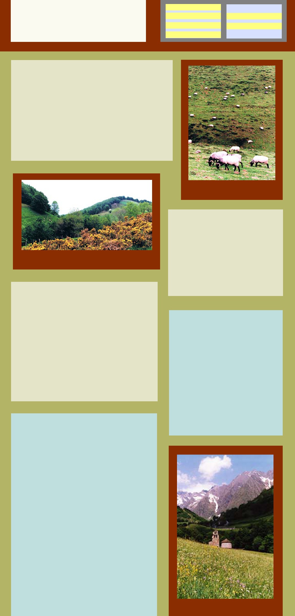
Mountain sheep graze near the GR 65
Looking towards Spain
A mountain chapel near the Spanish border
Looking towards Vignemale
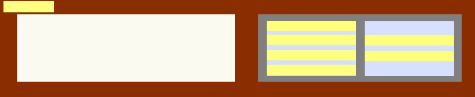
Advertising les Thermes de Cauterets
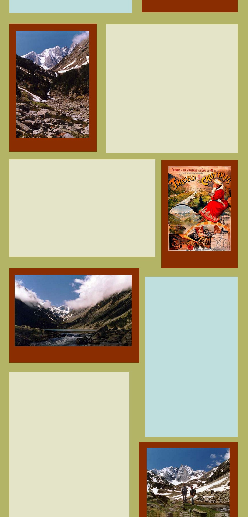
Mountain lake and Vignemale obscured by cloud
A perfect day
The Cirque de Gavarnie
Another perfect day
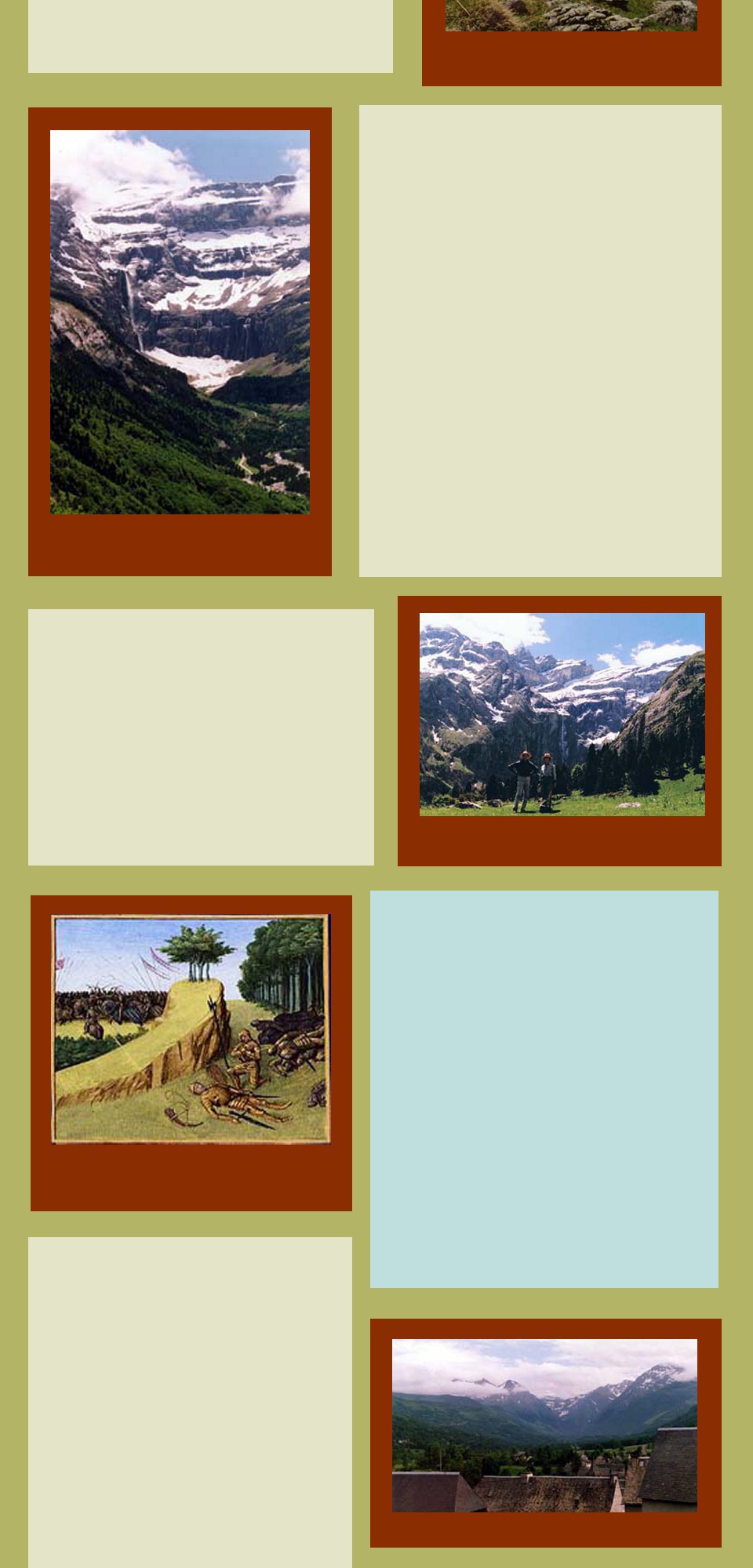
The death of Roland. Grandes Chroniques de France,
enluminées par Jean Fouquet, Tours, vers 1455-1460 Paris
The rooftops of Avajan and the mountains
Walking towards le Lac d'Oo
A mountain pathway
le Lac d'Espingo
Reserve Naturelle de Néouvielle
Explore more FRANCE
Visit ITALY
Visit SPAIN/PORTUGAL
Explore on MAPS
Return to HOME PAGE
Explore PHOTO GALLERIES